"You don't need a weatherman to know which
way the wind blows" Bob Dylan
Go to
https://www.windfinder.com/forecast/wabamun_lake
HIGHVALE WEATHER REPORTS - Dan
Kulak, from Environment Canada, gave an enlightening presentation at a 2002 AOSA meeting in
which he described how the thermal mass of the lake splits the weather as it moves
East. This is the force that creates the meso-climate (one
step larger than micro climate) on Wabamun Lake, sending rain to the
north and south. Hence,
Rainmaker Rodeo in St. Albert and the deluges that Leduc residents complain
about. Edmonton, on the other hand, receives generally drier weather and Spruce Grove and Stony Plain are actually one climate zone
colder than Edmonton, all thanks to that "little body" of water west of Edmonton.
The weather is reported by urban regions because tax payers live in them! The
following listing is in the order that Environment Canada broadcasts via the
weather channels.
- The region North of Wabamun includes Spruce Grove, Morinville, Mayerthorpe,
& Evansburg.
- The region South of Wabamun includes Drayton Valley, Devon (Nisku), Rimby
& Pigeon Lake.
- The region NW of Wabamun includes Whitecourt, Edson, Fox Creek & Swan Hills.
- Weather Station reports include - Edmonton International (Devon), Edson, Grande
Prairie, Rocky Mountain House, Stony Plain & Tomahawk.
- PS - You might want to print this list and attach them next to your VHF so it
is easier to follow a report.
What is important is that Wabamun Lake is NOT specifically included in any of these reports, being right in the middle of
the North and South regions. The N & S reports generally cover the
current weather at the lake and the NW report is key to predicting the weather two hours from
now, providing the wind is blowing from the west. A lake report must be extrapolated
based on wind velocity (speed and direction). Are you beginning to
see the difficulty of creating an accurate report for Wabamun Lake when
measurements aren't taken there? However,
click here, this view may help. Scrolling the bottom edge give you the
wind forecast and lots of other parameters.
HIGHVALE WEATHER STATION - Here are some
facts about the Environment Canada's reports that will give you a better
understanding of them when they were broadcast from the Highvale radio transmitter on VHF weather channel
WX3.
-
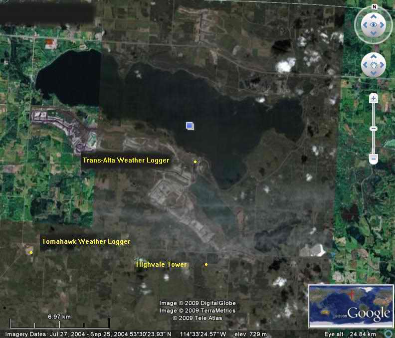 The Highvale radio transmitter
was located on a height of land 6.8 KM due south of
the Sundance power plant. At 114M above lake level it is well positioned
for good signal
coverage for Wabamun Lake. The only spot on the lake where you might experience
marginal reception is Sunshine Bay. This is due to the height of land
between the two. VHF radio
frequencies radiate basically line of sight and the Highvale antenna is just
below the "horizon" from Sunshine Bay, reducing the signal. This is generally
a problem associated with a hand held radio, not a mast head mounted antenna.
The Highvale radio transmitter
was located on a height of land 6.8 KM due south of
the Sundance power plant. At 114M above lake level it is well positioned
for good signal
coverage for Wabamun Lake. The only spot on the lake where you might experience
marginal reception is Sunshine Bay. This is due to the height of land
between the two. VHF radio
frequencies radiate basically line of sight and the Highvale antenna is just
below the "horizon" from Sunshine Bay, reducing the signal. This is generally
a problem associated with a hand held radio, not a mast head mounted antenna.
- The Trans-Alta weather logger, the device that measurers wind speed, direction,
temperature and rain fall is ideally located to measure Wabamun weather at the lake surface. This logger served boaters on Wabamun for many years
till Trans-Alta (owner) upgraded it to a newer model in the beginning of 2008.
Unfortunately the data format of the new logger is incompatible with the Environment Canada
network server. To maintain the Highvale broadcast service,
Environment Canada fed the transmitter with data from the Tomahawk weather
logger.
- The Tomahawk weather logger is NOT in Tomahawk, as the name would
suggest. It is located on a height of land about 8 miles South of Seba
Beach. Unfortunately the weather at this station is (usually) significantly different
from Wabamun Lake due to the meso-climate of the lake. This makes the reports from
Highvale marginally useful to boaters.
- There are many more weather loggers located around Alberta from which
Environment Canada gathers ambient data. The Doppler radar at Stony Plain is
used for advance detection of severe weather. It has an effective range of about
120 KMs with
reducing
accuracy beyond that. Weather data is gathered hourly and it takes
about 55 minutes to analyze; thus broadcast data can be delayed by 55
minutes to 1 hour and 55 minutes when the new cycle begins. It's a problematic thing.
While this is meets forecasting requirements for the surrounding land mass,
there remain two problems for boaters:
(1) boaters need near real-time current conditions
(2) boaters need data from the immediate area of Lake Wabamun.
A weather broadcast that is updated every 55 minutes is not too useful for a boater.
Wouldn't it be nice to have an on demand weather report, measured close
to the lake that also included barometric pressure for measuring dew point and
the possibility of fog? Go to
https://www.windfinder.com/forecast/wabamun_lake